Seamless Topographic Contour Overlays — 24 tiling transparent PNGs
A downloadable asset pack
Contour lines are one of the few patterns that read as terrain without drawing a single mountain. These are 24 of them, tiled seamlessly and cut out on transparency, made to sit underneath your work rather than to be looked at.
What it is
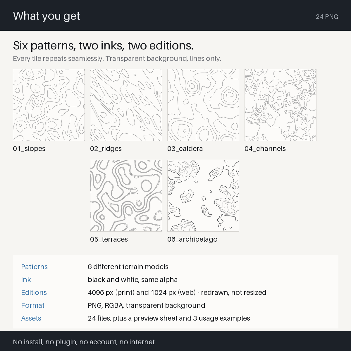
24 transparent PNG overlays of invented terrain, drawn as contour lines. Six patterns, black and white, at 4096 px and 1024 px. Every tile repeats seamlessly in all four directions.
Everything here is generated procedurally from mathematics. The height field is built in the frequency domain and the contour lines are solved analytically from it. No real map, survey, satellite image or terrain dataset was traced or referenced, and no third-party image, photograph or artwork is included.
That is also why the seams are not there: the terrain is built inside the repeating period, so no edge is stitched, patched or mirrored afterwards.
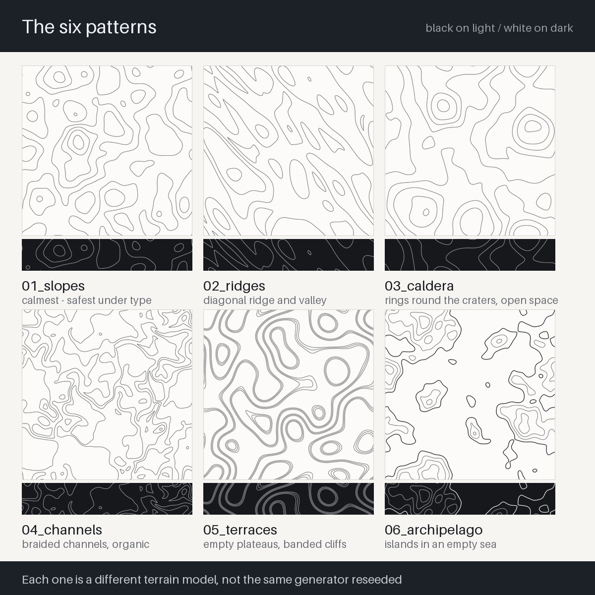
The six patterns are six different terrain models, not one generator run six times:
slopes- open rolling ground, the calmest: an even spread of lines with no strong directionridges- ridge and valley, gives a page a diagonal directioncaldera- craters on rolling ground; rings gather round the larger craters, the most open spacechannels- braided waterways, organic curvesterraces- stepped mesa, empty plateaus with cliffs bundled into bandsarchipelago- islands in an empty sea, coastlines as heavy outline
When you would use it
- Behind a game UI, a title screen, a loading screen or a map screen
- Under the text of a TTRPG handout, a rulebook page or a scenario PDF
- As a background for a zine, a book cover, an album sleeve, a poster
- As a stream overlay or a thumbnail background that is not flat colour
- Whenever you want the feeling of survey, expedition or fieldwork without drawing a map that has to be consistent
What it does
- 6 patterns x black / white x 4096 px / 1024 px = 24 PNG
- Tiles seamlessly in all four directions. Repeat one to cover any area
- RGBA with a genuinely transparent background. Only the lines carry colour, so you can recolour them to anything with a normal layer colour operation
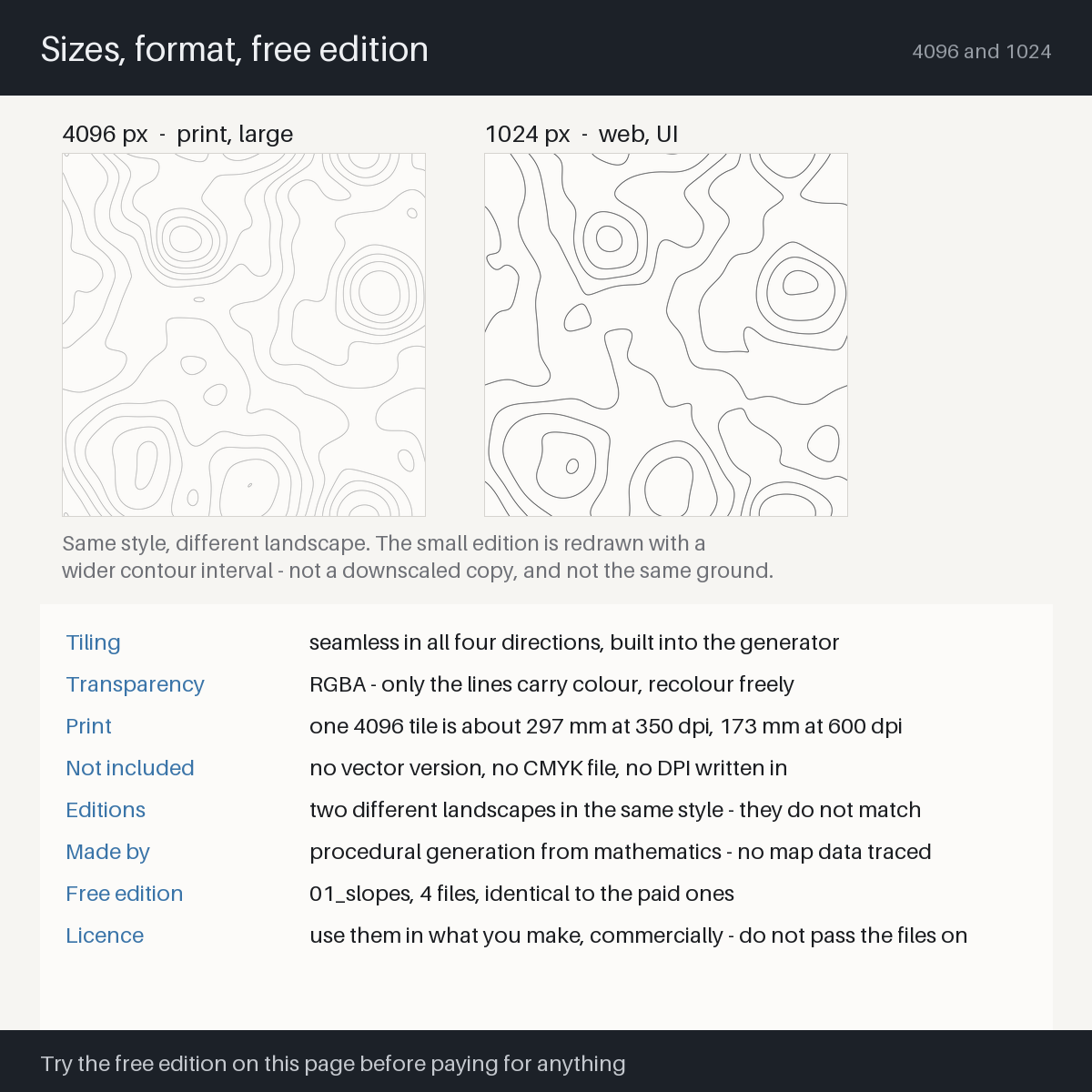
- The 1024 edition is redrawn, not downscaled. Its contour interval is opened up so the lines still read small - one tile is crossed by 1.4x to 4.7x fewer lines than at 4096, depending on the pattern (the included README lists all six)
- A constant line width regardless of slope, because the lines are solved from the field rather than plotted, so steep ground does not turn into a solid block
- Every contour line is closed - no line ends, no crossings, no stray dots; checked by machine on every build
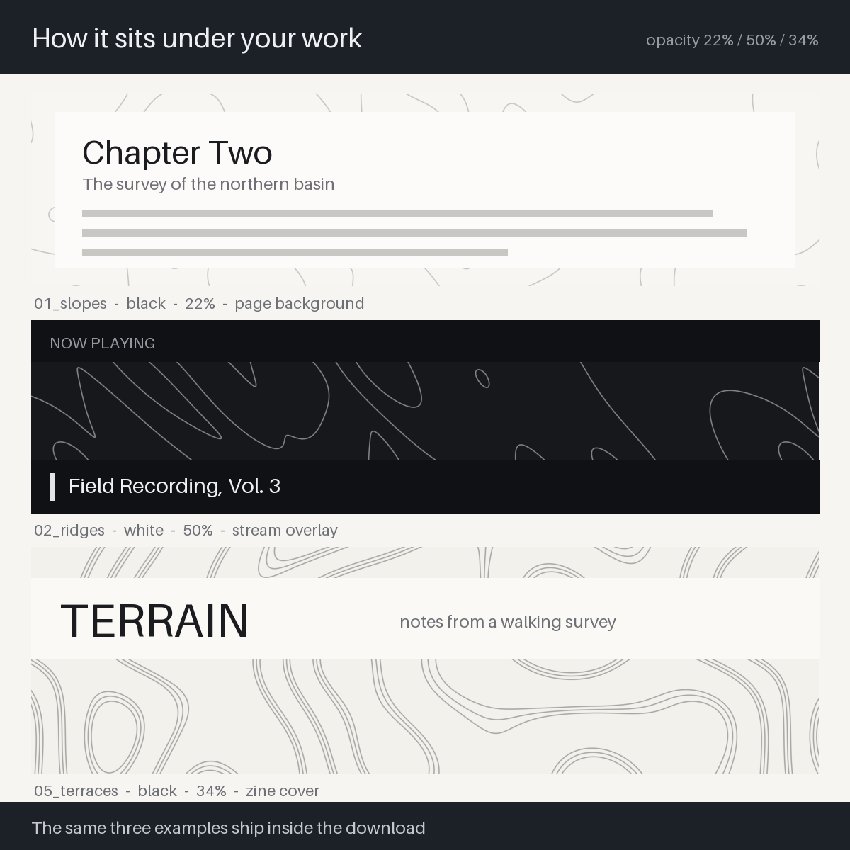
PREVIEW.pngshows all six patterns, both editions, on light and dark, with the file names printed on it, plus a band showing the 4096 files at 100% - you choose before you open anything- Three finished usage examples are included at 22%, 50% and 34% opacity, so the right strength is shown rather than described
- No install, no plugin, no account, no internet. They are finished images
What it does not do
Written here because otherwise you will assume it is possible.
- This is not a map generator and not a tool. There is nothing to run and no parameters to change. It is 24 finished images
- There is no vector version. No SVG, AI or EPS. Scaling far up, or changing stroke weight on its own, is not possible
- These are not print-ready CMYK files. RGBA with no ICC profile, and no DPI is written into them. Convert and set the size in your layout application
- No place names, heights, grids, coordinates or legends. It is texture, not cartography, and it will not pass as a real survey of anywhere
- "Seamless" does not mean "the repeat is invisible". Cover a large area and you will see the same shapes come round; the included README ranks all six patterns by how obvious that is
- The two editions are not the same landscape. Same terrain model and same seed, but the field is built at the size it is drawn at, so a 4096 file and its 1024 counterpart do not line up. Measured correlation between them is 0.011 or lower - the same as against an unrelated tile. If print and web have to match, take one edition and scale it yourself
- It will not gain a seventh pattern. Six is the product. The drawing was corrected once (version 2, 2026-10-06: every contour line is now closed and drawn at full strength); the file names did not change
How to use it
- Open
PREVIEW.pngand choose a pattern (if you cannot decide, take01_slopes) - Take that file out of the
pngfolder -_blackfor light backgrounds,_whitefor dark - Place it as a layer on top of your background
- To cover more area, duplicate it and butt the copies together - no auto-tile feature needed
- Drop the opacity to taste: 15-35% as a texture, around 50% on dark or when the pattern should be seen
- For anything under about 512 px, use the 1024 edition and raise the opacity to 40-70%
Easy things to get wrong
- The white files look empty in a file browser. They are white lines on transparency; there is nothing to see until they are over something dark
- Picking the wrong pattern for the size. Scaled far down,
06_archipelagokeeps its shape best, while01_slopesand03_calderafade to grain first. That is a choice to make deliberately, not a defect - Expecting the 1024 file to match the 4096 one. They are two different landscapes from the same terrain model, at different contour intervals. Compare them in
PREVIEW.pngbefore choosing, and do not split one job across both - Using 4096 tiles on a web page. They are for print and large canvases; the page will be slow for no visible gain
- Assuming the black will print as single-plate black. RGB 0,0,0 often converts to a rich four-colour black. Set K100 in your layout application if that is what you want
- A one-pixel gap between copies. The edges match exactly, so a visible seam means the placement is off, or each tile is being resampled separately
What you need
- Any image editor or design tool that can place a transparent PNG as a layer and change its opacity (Photoshop, Affinity, Clip Studio, Krita, GIMP, Figma, Canva, a game engine, a video editor - anything with layers and opacity)
- A PNG viewer alone is not enough, because laying them over something and tuning the strength is the whole point
- No automatic tiling feature is required - duplicating and butting the copies together works
- No install, no plugin, no account, no internet connection
- A free edition is on this page - one pattern, 4 files, byte for byte the same files as the paid edition. Try it before paying for anything
Download
Click download now to get access to the following files:
Leave a comment
Log in with itch.io to leave a comment.